13 September 2009 - Paix
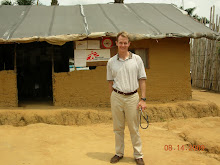
Go onto Google Earth and find me. I am southeast of Kisangani, the third largest city in Congo. When I first received this assignment from MSF, I did the same search. Lubutu was visible very early as I zoomed in. This is amazing as the town is comprised of a crossroads, a market, and lots of square houses (see photo below).
As you electronically swoop down, you will notice two airports southeast of the city. I knew the Congolese roads were awful and assumed I would be flying into the Lubutu airport. But why would this tiny town have two airports?

Both airports are the route of my one hour commute to Mungele. They are actually in the villages of Tingi Tingi and Amisi. They have airport codes like any other. The first time we drove to Mungele, I missed them. The road widens to about twice its normal size in these two villages. I figured I was excited by the jungle and waving at all of the children. Perhaps the terminals and runways were a bit off the main road, hidden by the vegetation. Oddly, there wasn’t any visible village of Tingi Tingi, just the widened road. What was this all about?

Congolese Petrol station I pass every day
When I was growing up in Indiana, Congo was called Zaire. Shortly after independence from Belgium, the country was taken over by a military strongman, Mobutu Sese Seko. He was an eccentric figure in my youth- a friend of apartheid-era South Africa, host of a boxing match featuring Muhammed Ali, and a plunderer of the national treasury. Eventually people grew weary of President Mobutu and a rebellion was launch in the east of the country. He was deposed and exiled. The country was renamed République Democratique du Congo (RDC). What follows is confusing. In eastern RDC there have been a series of armed rebellions and wars, some autonomous, others supported by foreign powers. These ongoing conflicts are centered in North and South Kivu Provinces. I am next door in Maniema province.
Tingi Tingi and Amisi were the scene of two huge refugee camps. They were the temporary home of people fleeing the war in the east. It appears that these camps were farthest west that many refugees reached before returning to the Kivus or Rwanda. The airports are these widened strips of blacktop. They were used by international aid organizations to fly in supplies. As the security situation deteriorated, the roads could no longer be used. This pavement allowed food and medicine to reach over 100,000 people.
There is ongoing conflict in the Kivus. Fortunately, Maniema province has recently been beyond the reach of major military activity. I’ve asked many Congolese what they want most for their country and the answer is unanimous. Peace.


No comments:
Post a Comment